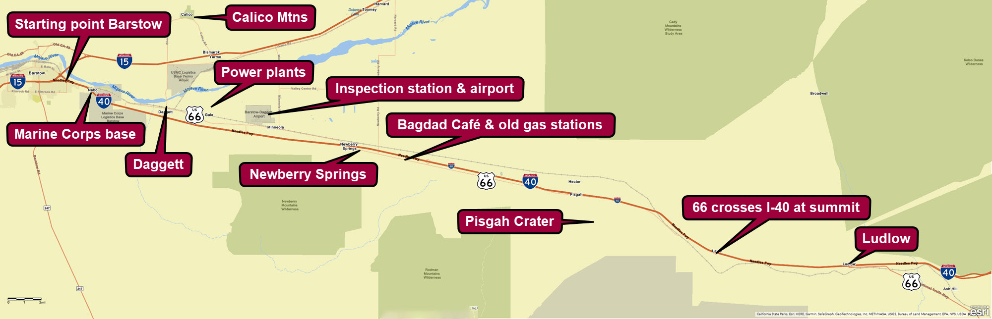
Route 66 Barstow to Ludlow
The most remote and barren stretch of Route 66 passes through California’s Mojave Desert between Barstow and the Colorado River, and the touring route described here covers the eastern half of it, between the towns of Barstow and Ludlow, and passing through the historic towns of Daggett and Newberry Springs. Driving this very remote part of the Mother Road back in the 1930’s made people nervous, and rightfully so. There was little traffic and, if their vehicle broke down, which they often did in those days, it was a long way to get help.

Trip Specs
Length
Attractions
- Classic Americana
- Historic old buildings
- Route 66 attractions
- Old experimental power plants
- Large desert vistas
Difficulty
- Roads are all paved
- Rough pavement on eastern half
Elevation Gain
The Tour
Our tour starts on the east side of Barstow, where our previous tour of Main Street through downtown Barstow, ends. If you’ve missed that, see Driving Route 66 thru Downtown Barstow. This tour ends in the remote desert outpost of Ludlow.
Along the way, this tour visits these interesting towns and sites:
- Marine Corps Logistics Base Barstow with its connection to the Tournament of Roses Parade
- Elephant Mountain
- Daggett – see the Daggett article
- Cool Water Ranch & power plants
- Barstow-Daggett Airport
- Newberry Mountain – see Newberry Springs article for more comprehensive tour
- Newberry Springs
- Pisgah Crater – see the Pisgah Crater article
This tour can be taken in either direction; from Barstow to Ludlow or Ludlow to Barstow. If you start in Ludlow, simply follow the tour itinerary in reverse.
Watch the virtual video tour below for a visual overview of driving this segment of Route 66.
Tour Map
Also see the interactive Google Map below.
Starting in Barstow
Begin your tour by driving to the east-end of Main Street in Barstow, where it passes underneath Interstate 40. You can also take the I-40 freeway and take exit #1. Reset your trip meter here.
There isn’t much to see along the 1.5 mile (2.4 km) stretch of Route 66 from exit #1 to the Marine Corps base. There used to be an old hotel and bar, but it was razed around 2010. If you’re not a serious or diehard Route 66 traveler, you can jump on I-40 and exit at Nebo Street (exit #5), which also bypasses the Marine Corps base.
Marine Corps Logistics Base Barstow
If you took Route 66 from exit #1, you’ll pass underneath I-40 again and in a short distance be stopped by the base’s main entrance. Just before the entrance stands an old gas station and hotel that was originally a Motel 6.
The alignment of Route 66 used to go right through the middle of this military installation. Until I-40 was built, Route 66 travelers drove right through the base as if it were another town along the road. Unfortunately, after the events of September 11, 2001, for security concerns, the public can no longer drive on this portion of Route 66 through the base.
The base is used as a supply depot and maintenance facility for the Marine Corps. It was originally established in 1942 to support the Pacific theater in World War 2. During this time, unneeded material, mainly wood for crates, were thrown away but picked up by locals to build many of the old buildings along Route 66. The base itself, has since grown to support the on-going needs of the Marines.
A satellite facility of the base was built later and called the Marine Corps Logistics Base Yermo Annex. It can be seen along this tour just north of our visit through Daggett. Here is where the Marines store a lot of their rolling stock. Trains can regularly be seen delivering or picking up the rolling stock, such as tanks, assault vehicles and JLTVs (Joint Light Tactical Vehicle).
An interesting side note about this facility, it is the home of a mounted color guard. Traditionally, this elite team of equestrians lead and kick off the beginning of the Tournament of Roses Parade on Pasadena’s Colorado Blvd, which ironically is also, Route 66.
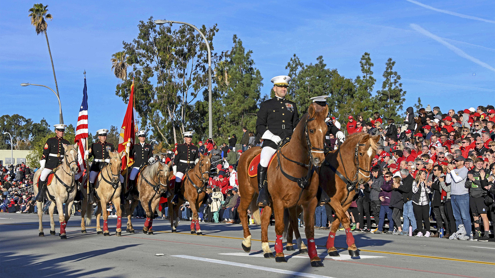
The above picture shows the Marine Corps Mounted Color Guard passing through the streets of Pasadena, California, during the 131st Rose Parade Jan. 1, 2020. The last remaining Marine Corps mounted color guard has participated in the annual Tournament of Roses Parade since 1985. (Picture curtesy Marine Corps Photo by Cpl. Nathan Hall)
To continue the tour, jump on I-40 eastbound at exit #2, drive two miles, then exit at Nebo Street (exit #5).
Whoop-de-doos & Elephant Mountain
After exiting Nebo Street, you’ll be connected back to the original alignment of Route 66 as it exits out of the east side of the Marine Base. Just like our tours of Route 66 from Victorville to Barstow, the old alignment is right next to the Santa Fe railroad trips, which are now owned by the Burlington Northern and Santa Fe Railway. These are the same railroad tracks that Route 66 roughly follows between Chicago and Los Angeles. There are many many “at grade” crossings of these same tracks and Route 66 along its entire length.
Between here and Daggett, you’ll experience the whoop-de-doos of driving through many dips in the road. These dips are caused by many drainage channels that run across the desert floor. These same types of channels are found all over the desert and cross Route 66 all the way into Arizona. When the roadbed was first built in the 1920s here (between Barstow and Daggett), it was simply built through these channels, causing the dips we’re experiencing now.
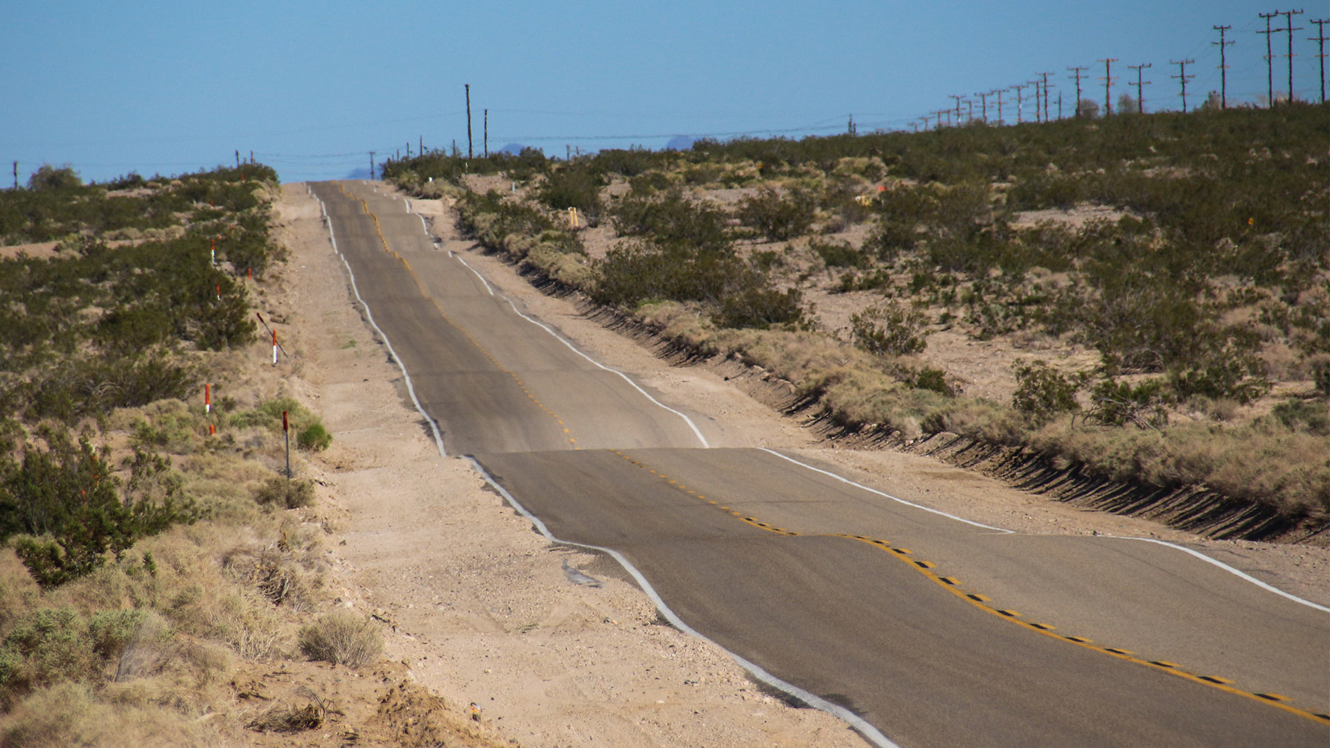
As we travel further east on Route 66, past Daggett, we’ll see that the road still crosses the many channels or ditches but now uses bridges instead. These were built in the 1920s and 30s, after it was determined that the road had too many dips for vehicles to drive through. By the ‘20s and ‘30s, vehicles by then were traveling faster than the normal 20-30 mph (32-48 kph) in previous years, causing newer vehicles needing to slow down for the dips.
In fact, and this might be hard to believe, Route 66 crosses more bridges between Daggett and the Arizona border than all the other bridges on the entire historic alignment of Route 66, from Chicago to Santa Monica. We’ll cover more on this topic on our next tour that continues east from Ludlow and into Needles.
Along this stretch of road, you’ll see a mountain come into view on the left. This is Elephant Mountain. It’s just across the sandy bed of the Mojave River from Route 66. Elephant Mountain saw several mining ventures that began the development of this area, mainly the town of Daggett, in the 1880s.
Elephant Mountain is also a significant archaeological site where debris, such as mill stones, pestles and mortars that were used by Native Americans, have been found here. There are also a few petroglyphs in a rock outcropping on the southern edge, as well as on an outcropping not far from Daggett-Yermo Road on the mountain’s east side.
Daggett
At about 7 miles (11 km) from I-40’s exit #1 (where we reset our trip meter), we reach Daggett. Although this looks like a forgotten and sleepy desert town, it actually has a lot of interesting history behind it and some of it is still standing around for you to go see.
Daggett had a lot going for itself back in the late 1800s. A lot of desert and Route 66 history occurred in Daggett; probably more than in any other town along Route 66’s path through the Mojave Desert.
Pictured below is an old AAA road sign from before Route 66 days was established in 1926.
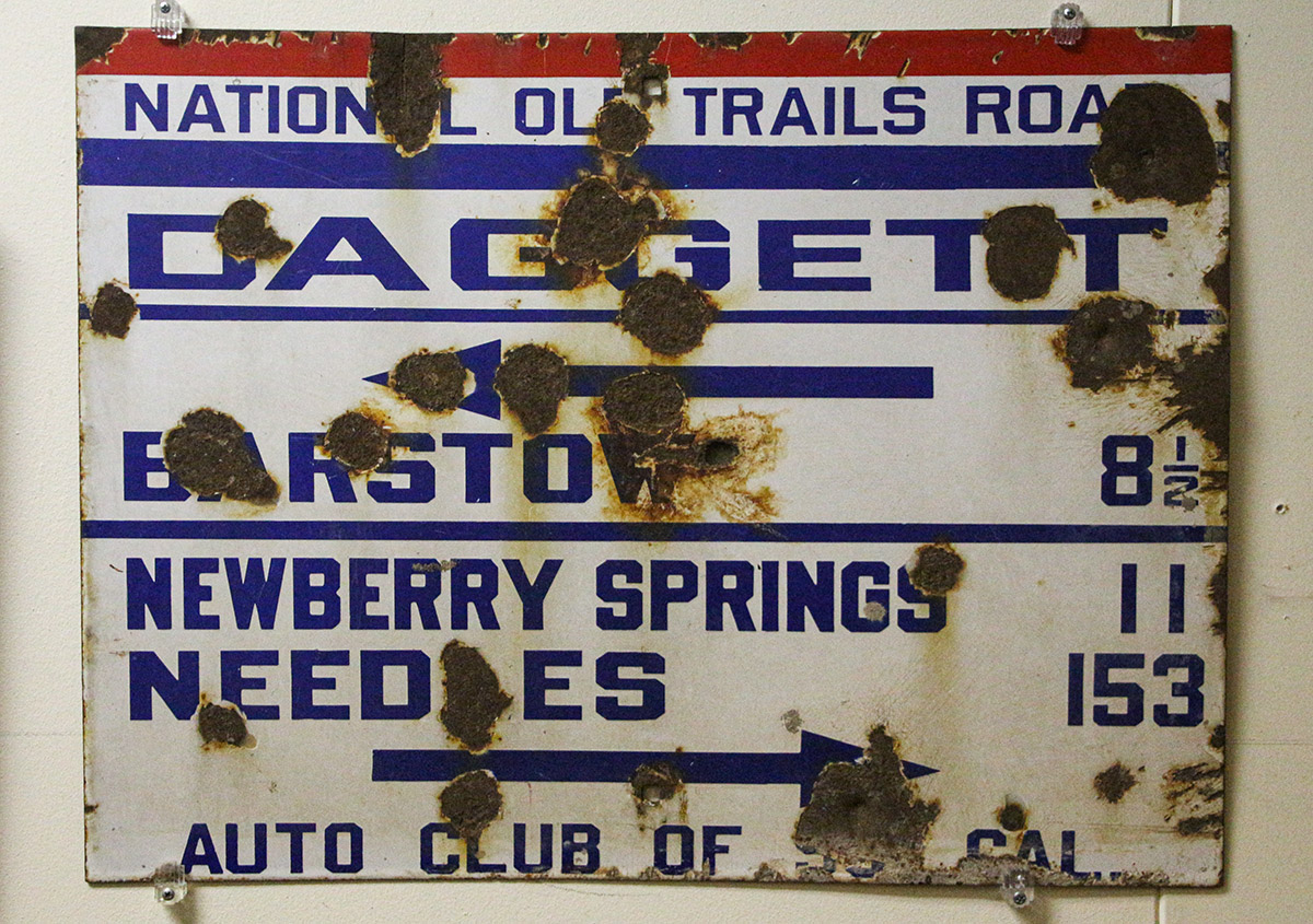
The townsite was first established because of small mines in Elephant Mountain mentioned earlier. The mining boom of both silver and borax in the nearby Calico Mountains, just 6 miles to the north, brought a lot more people into the area. In 1882, the railroad arrived, and Daggett was the closest point to the silver town of Calico. Ore was hauled by wagon to Calico and, from there, hauled by train for smelting.
When the National Old Trails Road was being established in 1912, that would later become the path of Route 66 through California (the road alignment we’re touring on), an enterprising blacksmith owner got a contract to create the road grade from Barstow to the Arizona border.
Just before reaching the stop sign, you’ll see this curious looking “Ski lodge” on the right. This was built in the early 1920s and was a standard design in those days used for California Welcome Centers. It was also standard to have an inspection station built nearby and there was one directly across the street from the Ski Lodge. Now it is a vacant lot.
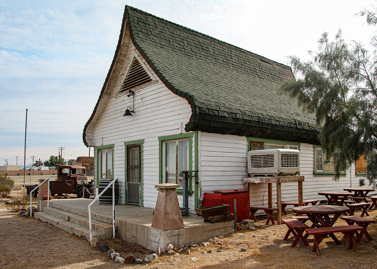
This inspection station is a big piece of Route 66 history, because it is the inspection station that actually appeared in the classic movie, the Grapes of Wrath, the movie that gave Route 66 that classic name, the Mother Road. In the movie, here’s where Tom Joad, played by Henry Fonda, was almost turned back. The real history is that this inspection station actually did turn back migrant workers in the Great Depression who were trying to escape the Dust Bowl of Oklahoma and the Great Plains.
When you arrive at the stop sign in Daggett, consider taking a detour to explore a little bit of this nicely preserved town with so much history. Do this, by turning left at the stop sign, crossing the railroad tracks, then turning right onto Santa Fe Street (the street directly across the tracks).
More About Daggett
Between Daggett & Newberry Springs
From Daggett, continue east on Route 66. You could have also continued east on Santa Fe Avenue, which connects back with 66 in 5 miles.
On the other side of the tracks from 66, or along Santa Fe Avenue, are several old ranches, along with the remains of several experimental power plants, one of which is still generating electricity today.
The Cool Water Ranch existed for over a hundred years and was still boarding horses a few years ago.
Just under 2 miles from Daggett, the Cool Water Coal Gasification plant is seen on the left. This plant was built in 1979 to convert coal into clean burning gas, which would be used in the neighboring electric power plant (closest to the road). The experiment concluded in 1987, but the power plant kept generating electricity using natural gas until it was decommissioned in 2015 and will likely be removed entirely at some point.
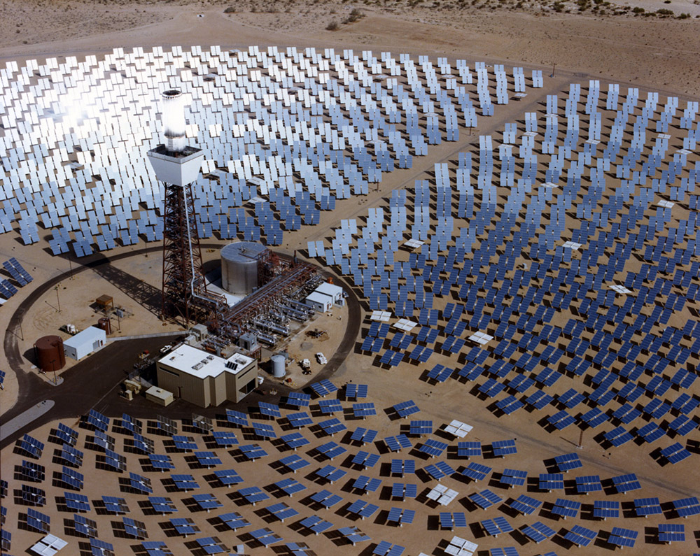
Next on the left are a series of solar power plants, which is about 3 miles from Daggett. The first one was called Solar One. It was the first large-scale solar electric power plant built in the USA. Built in 1981, it used 1,800 mirrors, to reflect the sun’s rays onto a central tower that would turn water, to steam and turn a generator.
Solar one operated until 1986 and was scrapped in 2009. Nothing exists at the site today and it currently is situated behind the newer solar power plants. Those newer power plants are currently operating. One of the plants is significant because it was the first one to utilize a system of parabolic mirrors that heated a special liquid that turns a turbine to spin a generator. This type of system is now widely used at many plants, including several around the Mojave Desert.
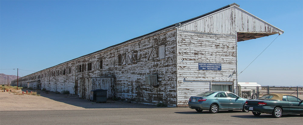
At 5 miles from Daggett, an optional left turn onto Hidden Springs Road leads to the Barstow-Daggett Airport. It has some history as it was built in 1933 and used for various projects during World War 2. A very large old hanger, that is interesting to look at, is still in use for sheltering aircraft. Built by Douglas Aircraft that made the DC-3 aircraft made famous in World War 2, originally there were 3-4 of these hangers. The County owned airport is still used by the Army in conjunction with nearby Fort Irwin.
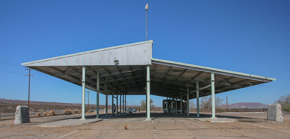
Back on Route 66, and not too far from the airport, is another inspection station, this one was exclusively used for agricultural inspections. It was built in the 1950s and replaced the one in Daggett.
Vehicles coming from the east were thoroughly inspected. Travelers were asked to open their suitcases so that inspectors were satisfied that nobody was accidently bringing in contaminated fruits or vegetables that could easily devastate California’s huge agricultural business. After I-40 was completed in the early 1970s, a new inspection station was built on the Arizona border, and this one has been in a state of disrepair ever since.
Newberry Springs
Continuing east another 6 miles brings us to the town of Newberry Springs. As we approach, notice this taller mountain on the right. This is Newberry Mountain.
RESET YOUR TRIP METER after passing under I-40.
The first thing to see on the right is the original highway maintenance yard built in the 1920s when the roadbed for Route 66 was being built. There are a few buildings left where the maintenance workers lived. As of 2022, the property is privately owned.
Next on the right after the maintenance yard is the Deel Plumbing Hardware Store, which was originally the Cliff House that was established in 1929. It was a full service desert oasis that included a garage, store, café, cabins, post office and general store. In the 1950s, both Greyhound and Continental Trailways bus companies stopped here. It also had the only telephone in town, which made it quite the popular place. An old pool and cabins can be seen in the back. The site is on private property.
Inching a little further down Route 66 brings us to a popular watering hole named, The Barn, on the left. On the weekends, you can expect the barn to be enjoyed by bikers and Route 66 travelers alike.
When you walk into The Barn, you’ll get to see plenty of old-time memorabilia from Route 66’s heyday, plus you’ll get a good idea of what a typical roadhouse looked like back then.
About 3 miles (4.8 km) from I-40, one of the biggest attractions that everyone wants to see on this section of Route 66 is reached, the Bagdad Café. Originally named the Sidewinder Café, this place was made famous by a 1987 movie named Bagdad Café. The movie has a cult following. Thanks to the movie and some other factors, it is now one of the most popular stops that tourists want to make along the entire stretch of Route 66. Like The Barn, there is also a lot of Americana memorabilia to see here.
The movie and the café were actually named after another Route 66 town called Bagdad, which is 50 miles to the east from Newberry Springs. Bagdad is truly a ghost town now, as there is nothing left but desert and a few foundations.
There used to be this adjoining hotel to the cafe, which was used in the movie, but sadly it was razed around 2016. However, the old motel sign still survives. As of 2022, efforts are underway to preserve this classic sign.
RESET YOUR TRIP METER at Bagdad Café, then continue east. Soon, we’ll see two classic old gas stations that existed during Route 66’s heyday, the first one being this Whiting Brothers gas station.
Whiting Brothers was a chain of gas stations that started in 1926, when Route 66 was commissioned. This one sits on private property now and is rather photogenic. The next gas station, just down the road a short distance, is in much better shape. This gas station was not part of a chain like the previous one.
More About Newberry Springs
Pisgah Crater & Lava Flows
At 2 miles, the intersection with Fort Cady Road is reached. Many people jump on I-40 here to continue their Route 66 journey eastward. The pavement on the roadbed starting at this intersection becomes more deteriorated. However, serious and diehard Route 66 fans will want to continue past this point, regardless of the bad pavement, so that they don’t miss anything, including Pisgah Crater.
About 7.5 miles from Bagdad Café, the scenery changes as Route 66 begins passing through basalt flows, which marks where molten lava once flowed out of Pisgah Crater, which comes into view on the distant right.
Located in this basalt flow is the Hector Mine. Unique minerals found nowhere else are mined here in the basalt flows. This area was the site of the magnitude 7.1 Hector Mine earthquake in 1999.
From Route 66, about 15.5 miles (24.8 km) from Bagdad Café, a badly paved road will lead towards the crater and is labeled Pisgah Crater Road on most maps. If you drive up the roughly paved road to the crater from Route 66, you’ll get to experience a very unique landscape. Cinder was mined from the crater on and off for the past several decades, which doesn’t make it very recognizable as a cone shape anymore.
The eruption created several lava tubes. These are essentially caves and are open for exploration. The basalt or lava rock surrounding Pisgah Crater has the largest concentration of caves in southern California.
Just past Pisgah Crater is the border to the Mojave Trails National Monument. This relatively new national monument preserves the heritage of several historic roads through the Mojave Desert, including Route 66.
More About Pisgah Crater
Continuing East
Continuing east on 66, you’ll cross over to the other side of I-40 with good views of the desert in both directions. The desert outpost town of Ludlow will be reached in 29 miles (46 km), from Bagdad Café. Ludlow marks the beginning of the next Route 66 tour. Look for that tour sheet that covers even more remote stretches of the Mother Road, to US Hwy 95, near Needles.
If you decide to continue east on Route 66 past Ludlow, be sure to at the Route 66 Ludlow to Needles article.
Virtual Video Tour
