Calico Mountains Dirt Road Adventure
The Calico Mountains near Barstow offer a treasure trove of hiking and opportunities for exploring back roads, along with unusual geologic formations and classic California mining history. Best known for the Calico Ghost Town, not many people are aware of what lies behind the famous ghost town. Several days can be spent exploring the different corners and fascinating places to see in the Calico Mountains.

Trip Specs
Length
Attractions
- Rugged colorful mountains
- Rugged canyons
- Historic mines
- Desert vistas
Difficulty
- Must have 4WD high-clearance
- Difficult to navigate
- Easy to get lost
Elevation Gain
Written by Cliff & Ilene Bandringa
Not only are the Calicos full of history and geologic fascination, they live up to their name by being very colorful. Exploring the Calico Mountains can easily take a full day, but after you see them on this introductory trip and discover all of the inviting dirt roads, you may find yourself going back again and again to check out all of its hidden corners.
This trip requires that you have a 4WD vehicle with good ground clearance. You need to also have experience in driving on rough terrain because there are challenging spots along the way. Your vehicle could sustain some serious damage if you are not familiar with its limits. If you don’t have such a vehicle, you can still drive a portion of the trip and get a glimpse of what’s inside the colorful Calico Mountains. Read on and we’ll tell you where only 4WDs should dare to tread.
Tour Route
Be advised that of all the maps we’ve looked at covering the Calico Mountains, none of them cover the roads mentioned in this article. Mule Canyon Road is on the map, as well as an extremely rough 4WD road through Odessa Canyon (which we don’t cover in this article), plus a few other roads, but most other roads are not mapped. Even the BLM map shown on the kiosk posted in some places in the Calicos does not show all the roads. Aerial imagery available in Google Maps is really the only good source of maps, but even those don’t show spots that are impassable. So having a good instinct for trail finding and being aware of previous (recent) tire tracks is important when exploring the Calicos.
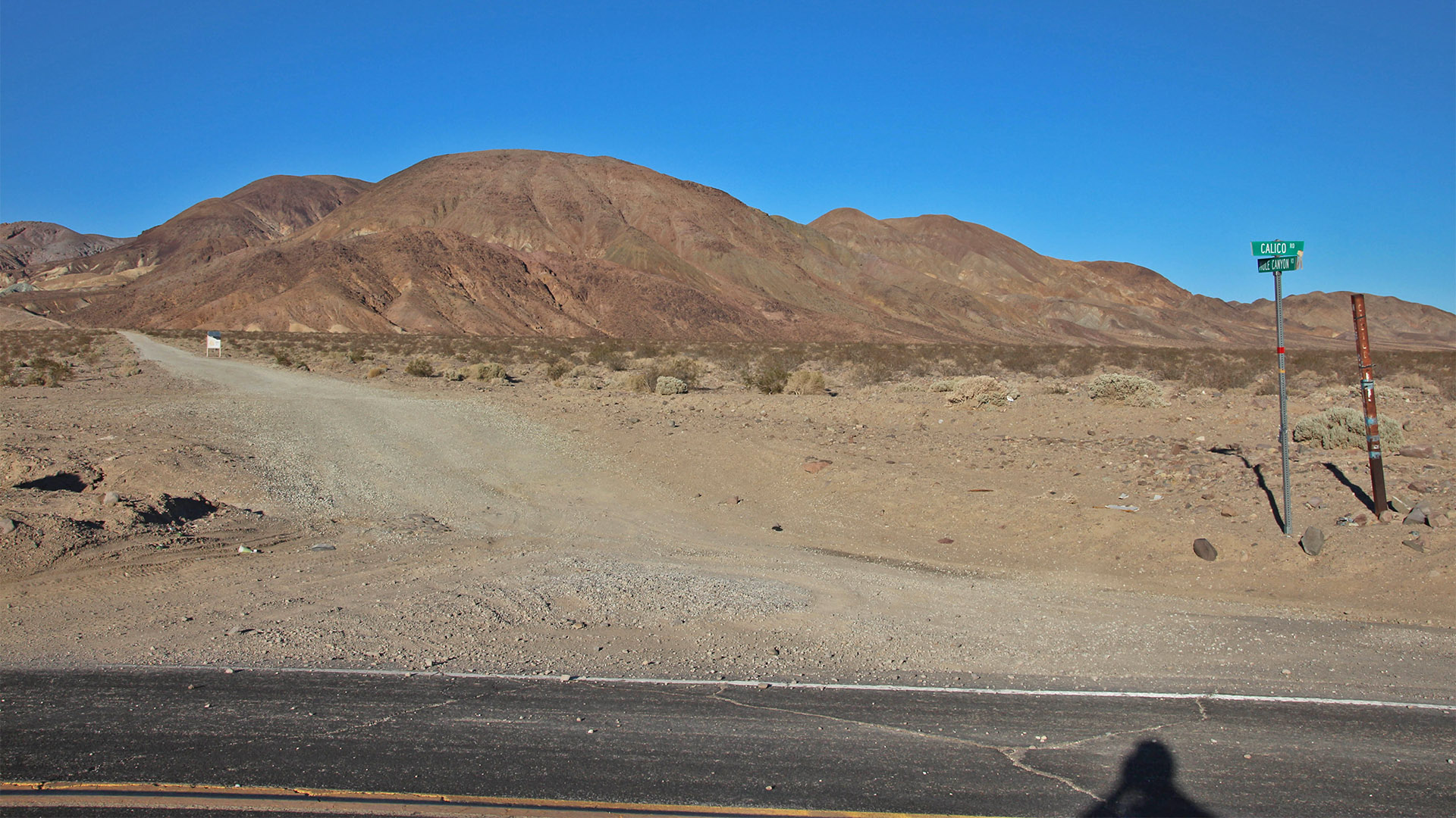
With our many forays into the Calicos, we’ve usually started going up dirt Mule Canyon Road from paved Calico Road (one mile north of I-15). But there are many ways to get into the Calicos. This article explains our suggested touring route starting from this point (Mule Canyon & Calico Roads). Reset your mileage counter at this junction.
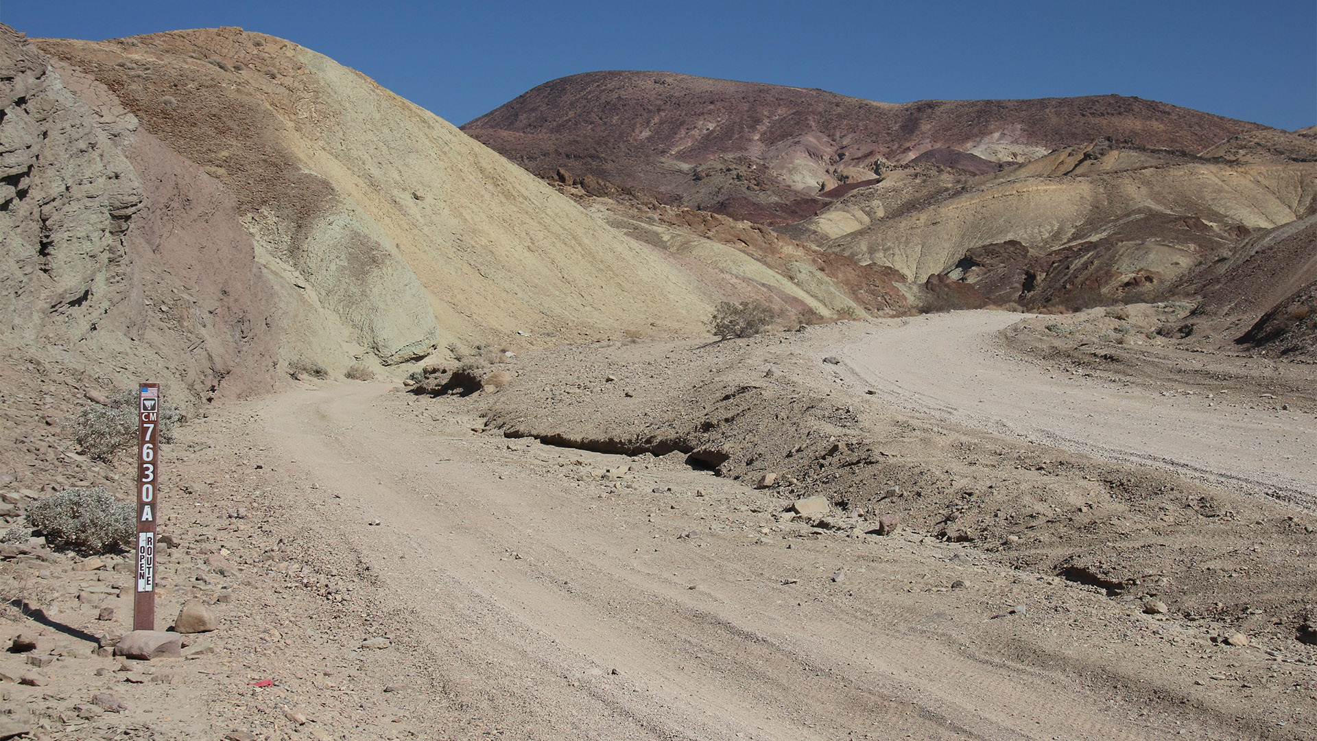
About two miles in, a fork in the road is reached. Take the left fork. This is usually marked as BLM Road 7630A. See what the fork looks like in the pictures below.
Continue on 7630A for about 1.2 miles (reset mileage counter again). This road becomes very rough after 0.3 mile. At 1.2 miles, the road goes along a ridge overlooking Odessa Canyon with spectacular views of its west side. At 2 miles from the fork, the road descends into Odessa Canyon. At 2.2 miles, turn left (west) onto another road that climbs a drainage out of Odessa Canyon.
At about 3 miles from the fork, the road crosses a ridge and descends into the next canyon to the west. The “gopher digs” of the Bismarck Mine will be seen at the end of the road at the bottom of the canyon.
There are many roads that lead away from the Bismarck Mine. It can be very confusing. Take the lowest road that leads towards the northwest. This road follows the bottom of a wash that at some point will be impassable. Look for roads that go to the right to head north, then take other roads that lead back to the west. There are many small mines in this area, all with roads going in different directions. Look for the most traveled road. Eventually, a major dirt road named Wall Street Canyon Road that leads north will be encountered. This road will lead to the pavement of Fort Irwin Road, which is the end of the tour.
See the Map below to see where key points are along the tour.
Lots of Mines
As mentioned, the Calicos are also full of historical mines. There are literally hundreds of open mine shafts scattered throughout the Calicos so be very careful. Some mines are vertical shafts (deep holes in the ground) that anyone could easily step up to, loose their footing, and fall into. There are even a few vertical shafts right next to the road so, even as you step out of your vehicle, pay attention and look before you step! You are a long way from getting any help and some of the shafts are deep enough that you may not survive. That said, don’t let this keep you from exploring. Just be aware and use caution.

Tour Description
As mentioned, our suggested tour route starts on Mule Canyon Road close to I-15. Head up the alluvial fan that leads to the mouth of Mule Canyon. Reset your mileage counter after you leave the pavement of Calico Road.
Mule Canyon
The road you are now driving on got its name for a very good reason. Remember the famous 20-mule teams that brought ore across the desert from Death Valley? Well, after they were used at the borax mines there, the same mining company brought them here to be used. Further up Mule Canyon was a large borax mine that operated in the last part of the 1800s. At the time, the Calicos were the world leader in borax production. Ore was brought from the mine to the town of Daggett on this road where it was then shipped out by railroad. If you look behind you, you’ll see the old road continue across the valley towards Daggett. Later, a narrow gauge railroad was built on top of the road you are now driving. That operation lasted until about 1905. See the article on Daggett to learn more about this town’s relationship with the Calico Mountains.
Soon, you will be in Mule Canyon. You’ll notice the colorful hills of different hues indicating that there are many different types of minerals in the dirt. In 1.4 miles, you’ll reach several rocky outcroppings known as Camp Rock. This area is popular with people who enjoy exploring by motorcycle or ATV. Often, those people will park their RVs here to camp. It is common to see many people camping here on weekends and it can even be a little crowded.
As described earlier, at 2 miles from the pavement, leave Mule Canyon Road by bearing left at a fork. Mule Canyon Road continues several miles to the east and can easily be explored in 2WD. At 2.1 miles (now on road 7630A), you’ll pass through some contorted landscape. This is evidence that the Calico Mountains are heavily faulted and earthquakes are common. Park off the road here to get out and see all the crazy formations on both sides of the road. This faulting can be traced in both directions for several miles.
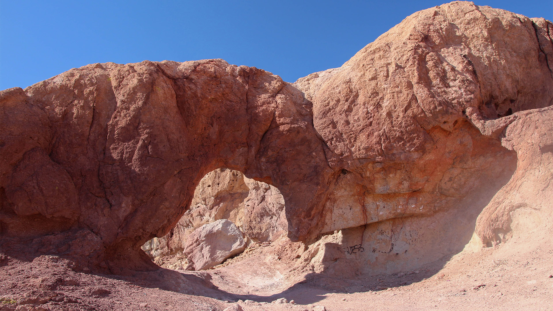
Kramer Arch
Continuing a short distance, our next stop is at 2.3 miles. If you don’t have a 4WD, don’t go past this point to continue on the main road.
On the left is a parking area where you can park, then hike about half a mile up over a ridge to see Kramer Arch. If you’re really good with your 4WD, you can attempt to drive it, but the road is very rough. This natural arch, located due west of the parking area, is a prelude to the wild and crazy landscape you’ll see further along on this trip.
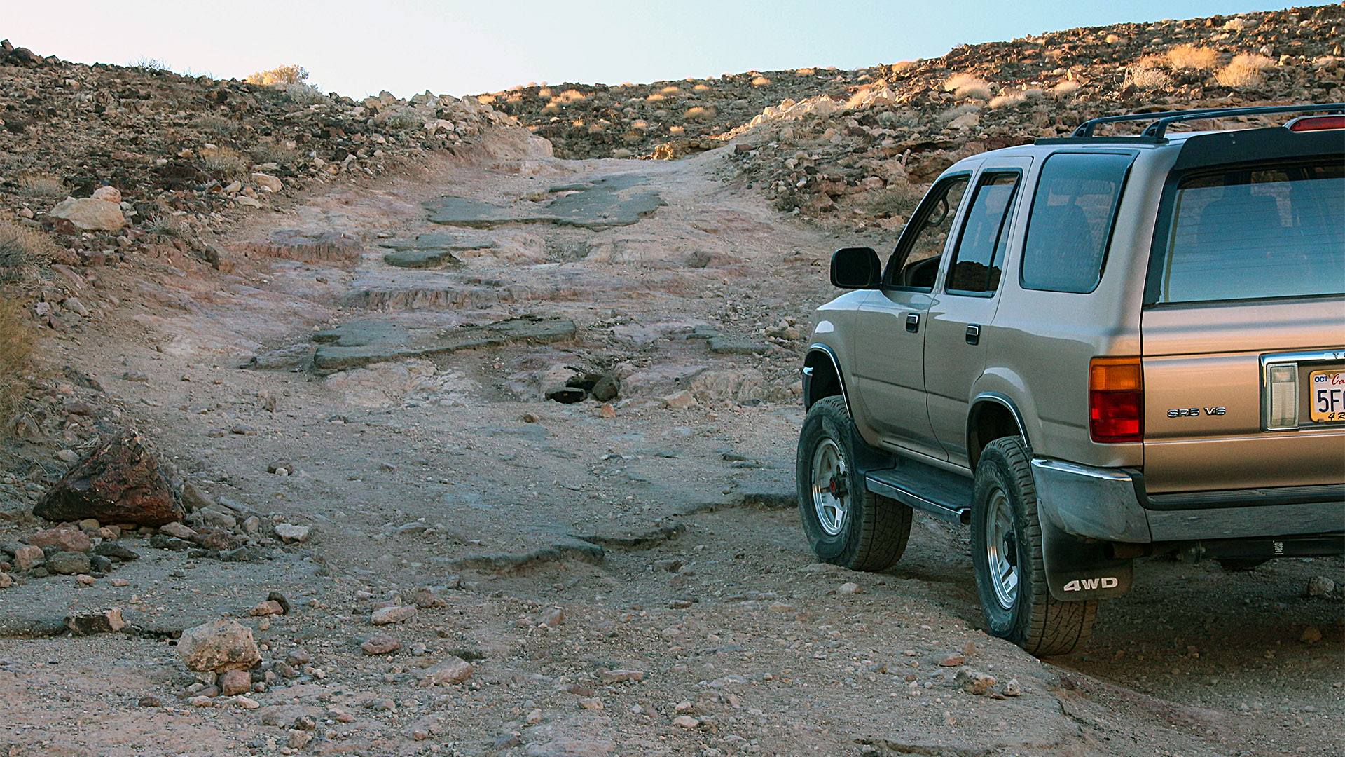
The Road Gets Rough
Our first rough section of road is at 2.5 miles and this is where you’ll need that 4WD. Here is also where we’ll start seeing a lot of mine shafts including a vertical shaft right next to the road. The road is very steep here and the difficulty is compounded with big chunks of old pavement. In the 1950s, this road used to be paved and was a one-way scenic loop that regular automobiles could travel on but it was washed out during a downpour. Before tackling this section of road, you may want to get out and walk the hill so that you are familiar with what you are about to be driving over. This rough spot is only the beginning of your 4WD driving challenge, as there are more bumpy spots over the next half mile. Make sure to start out in your vehicle’s low-4WD setting.
Odessa Canyon
As you follow the main road that heads west, you’ll pass by a few more mines and some distorted landscape and, at 3.1 miles, you’ll come up to the top of a ridge of a deep canyon. Here, the road turns right (north), but before continuing, use the large turnout near the turn to enjoy the view into the deep canyon below. This is Odessa Canyon. Opposite the turnout (across the canyon) are the remains of the huge Odessa Silver Mine. This mine operated between 1882 and 1896 and was one of the biggest producers in the Calicos. All you will see today are many holes, or mining adits, where ore was taken out of the hills. Watch the virtual video tour below to see what the remains of the mine looked like in 1950.
Continuing on our trip, head north on the road along Odessa Canyon. In 3.7 miles, the road will descend into the canyon and, at 4 miles, make a left turn out of the canyon onto a well-defined dirt road. Continue following this road as it turns left and right and slowly gains elevation. In about 4.7 miles, you’ll reach a summit and see a vista of the Calico Mountains to the west. You will also see the bizarre workings of the Bismarck mines just below. From the summit, bear left on the road (bearing right will be a more challenging downhill) and then turn right to reach Bismarck.
Below is a panorama from the lookout on road 7630 looking west over Odessa Canyon and the remains of many silver mines on the opposite side of the canyon. Calico Peak is the tallest point in the Calico Mountains at 4,491 feet (1,369 m).
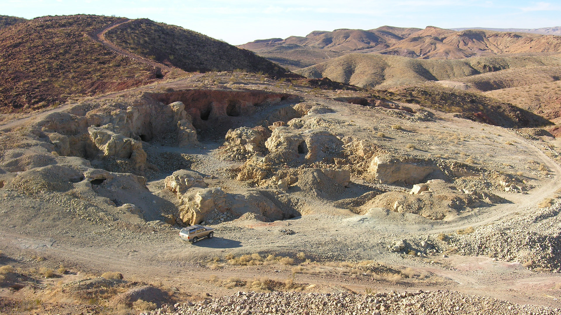
Bismarck
Bismarck is the site of numerous mining operations. Although most of the mines in the Calicos were for silver, many different minerals were extracted from the Bismarck, including gold. The last operation at the Bismarck exposed all of the older underground workings and left them looking like gigantic open caverns. Geologists refer to this style of mining as “gopher digs”. We’ve explored a lot of old mine sites across the Southwest but we’ve never seen a mining operation quite like this one.
Park your vehicle along the road that goes to the left of the first diggings you see. This is also a nice high spot to survey the surrounding area and the valley below. Although it is very dangerous to walk through old mines and we don’t suggest you attempt it, we’ve seen many people explore the workings of the Bismarck. When you do explore the area, don’t miss the diggings above the area where you parked your vehicle and don’t forget to watch where you step. If you continue walking to the south, towards the valley below, you’ll see numerous digs.
Epilog
Although our Tour Route above mentioned continuing on to Fort Irwin Road, we’re ending this introductory trip into the Calico Mountains here but there is so much more to see in this area that you just can’t squeeze it all into one day. There are so many roads leading off in different directions and they’re all screaming to be explored!
More Pictures


Virtual Video Tour
