Afton Canyon
Often referred to as the “Grand Canyon of the Mojave”, Afton Canyon is a colorful, steep-walled canyon that was created by a massive flood nearly 18,000 years ago. Today, the Mojave River continues to carve the canyon ever deeper but at a much slower pace. This is one of the only spots along the river’s 140-mile length where water flows above ground all year.

Trip Specs
Length
14.1 miles (22.5 km) to Basin Rd
Attractions
- Unique and colorful geology
- Slot canyons
- Hike to the “Caves”
- Historical Mojave Road sites
- Railroad trestles and bridges
Difficulty
- Must have 4WD high-clearance
- Seasonal high-water crossing
- No phone service
Elevation Gain
Although this Road Trip requires a high-clearance, 4WD vehicle, the beautiful canyon scenery is also accessible on foot. Class A vehicles can park at the campground located at the western entrance of the canyon and hikers can follow the road for as far as they want to go.
Getting There
Afton Canyon can be accessed from either end of this road trip and each end has an exit from Interstate-15. The route we describe starts at the Afton Canyon Road exit (western end), heads generally eastward, and ends at the Basin Road exit. To take the trip in reverse, exit Interstate 15 at Basin Road and follow the directions in this article in reverse.
You will need a vehicle with both 4WD and high-clearance to complete this Road Trip. Although the starting and ending sections can be done with a Class A vehicle for a short distance, there are two river crossings and patches of soft sand that cannot be safely crossed without the required vehicle. For those who do not have that type of vehicle, parking at the campground and hiking into the canyon can also be very rewarding.
Be sure to have plenty of fuel and supplies before heading out on this Road Trip. The nearest supplies are either in Baker (20 miles to the northeast) or in Yermo (26 miles to the southwest). From time to time there are gas stations and/or convenience stores at the other exits nearby but they are unreliable.
Restrooms are located in the Afton Canyon campground at the western end of the Road Trip. There are about 12 campsites, all with picnic tables and firepits.
Below are pictures of Afton Canyon Road from I-15 and the Afton Canyon Campground.


Alternate Entrance
In case the water crossing by the campground is to deep to cross, there’s another way to get into Afton Canyon. Get back onto Interstate-15 at the Afton Canyon Road intersection and head north towards Las Vegas. Continue on I-15 for 8.6 miles to the next exit, Basin Road. Take this exit and turn right (south).
Like Afton Canyon Road, Basin Road turns to dirt just after leaving the intersection. The road is typically in good condition because it is a mining haul road. Continue on it for two miles. Bear left at a Y intersection. Bearing right will lead to the mine.
In another two miles, the road will reach the railroad crossing described in The Road section below. After this point, simply follow the directions below in reverse until you come to the deep water.


The Road
The entire length of the road through Afton Canyon is dirt and, as stated in Getting There, you will need a vehicle with both high-clearance and 4WD for the spots with deep sand and for the two times you will cross the Mojave River. At both river crossings, be sure to get out of your vehicle and test the depth of the water before deciding whether or not it is safe for you to cross. The Mojave River typically runs higher in the winter but summer thunderstorms upstream can make the river swell quickly and generate flash floods so be cautious any time of year. There will be times when even a high-clearance vehicle will not be able to cross the river.
Some sections have been overgrown by the thick vegetation of the salt cedar bush. The best way to get through these sections is to follow the previous tire tracks until the road clears again. The salt-cedar, a very invasive bush, spreads quickly in the washes of Afton Canyon and is an on-going problem for the BLM (the organization who manages Afton Canyon). They have been working hard to eradicate this non-native plant and have been aggressively burning them (which seems to be the only way to actually kill them).
Another tricky navigational spot is at the exit of the canyon near the third steel railroad bridge. A few hundred feet before the railroad bridge is a road leading off to the right and up a hill. At the top of the hill is a great view of the Devil’s Playground. This road continues on and will eventually lead back to Interstate 15 but we don’t recommend it because it crosses the railroad tracks at a point where trains are often stopped for long periods of time.
After enjoying the view, turn around and return to the riverbed route you were on. If there are no trains blocking the tracks, continue on this road east and cross at the railroad crossing. Or, go under the railroad bridge and continue eastward, following the best tire tracks/route until you are lead to the right (south) and out of the riverbed. Follow this road for about 0.75 miles (1.2 km) as it goes along the railroad tracks and then turn left (north). Continue until it meets with the well-graded road of the mine then take that road to the Basin Road on/off ramp of Interstate 15.
Distance
Driving distances from the Afton Canyon Road exit at I-15:
- To the campground, the distance is 3.4 miles (5.4 km)
- Second steel bridge and second river crossing: 4.7 miles (7.5 km)
- Main part of the canyon: 5.7 miles (9.1 km)
- First slot canyon: 7.0 miles (11.2 km)
- Third steel bridge: 8.7 miles (13.9 km)
- Basin Road exit at I-15 and total route distance: 14.1 miles (22.5 km)
See Map below pointing out various points along the tour.
Pictures of road in main part of Afton Canyon:


Geology
Many geologists believe that the dramatic, sheer walls of the Afton Canyon we see today were carved in only a few days when a massive flood rushed through the canyon approximately 18,000 years ago. Back then, the hills surrounding Afton Canyon were a natural dam for the Mojave River and helped to create a large, ancient lake called Lake Manix. From the mouth of today’s Afton Canyon, this lake stretched west almost to modern-day Barstow and southeast into the valley that today is traversed by Interstate 40 and was approximately 1,800 feet (550 m) deep according to the shoreline rings that were left behind.
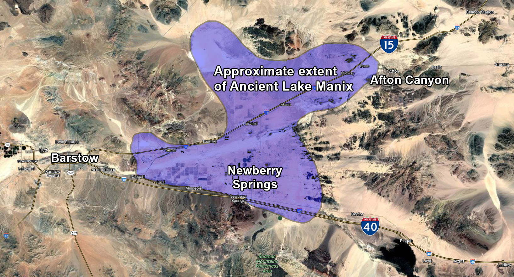
Geologists today have two possible theories as to how this large lake was drained in such a short amount of time. One theory is that the Manix Fault, a major fault that runs along the west side of the hills of Afton Canyon, moved. This movement created a breach in the natural dam of Lake Manix and the huge volume of water of the lake that had been held back now rampaged through the canyon, completely draining the lake in as little as a few days! This still-active fault moved again in 1947 and produced an earthquake registering 6.2 on the Richter Scale.
The other theory is that an extremely wet season filled the lake to the brim where the water encountered a softer, more vulnerable section of the natural dam. The water eroded this section to the point where the dam was breached and, once started, the water could not be stopped. As in the other theory, the lake was drained in a very short time – somewhere between three days and two weeks.
Water, of course, travels downhill and the floodwaters from Lake Manix flowed and spread out into the Devil’s Playground, Soda Lake and Silver Lake (north of Baker). After the creation of Afton Canyon, Lake Manix never formed again and the official end of the Mojave River today is at Soda Lake with an occasional overflow into Silver Lake.
Further evidence that there was once a lake here are the small, rounded rocks you can see just off the paved road after you exit the freeway at Afton Road. Pull off the road just southeast of the freeway overpass and take a look at the pebbles on the embankment of right side of the road. You’ll see that they are “beach rocks”; tumbled, rounded and smooth.
Mining in and around Afton Canyon has been going on for almost a century. Magnesite (Magnesium Carbonate) was mined briefly in 1917. This mine employed a 1,900 foot (580 m) aerial tramway (now gone) to carry ore from the top of the canyon down to the railroad below. Although there was nearly 200,000 tons of ore on the side of the canyon (just east of the slot canyon pictured below in the Photo Tour), only a few train car loads of ore were actually shipped away to be milled. The rest of the ore is still within the southern wall of Afton Canyon today.
As of 2003, there was a large limestone and marble mining operation on the east end of the canyon. This operation is the reason for the well-maintained section of road between the mine and the Basin Road exit. There is another, older mine located about 0.2 miles (320 m) northeast of the third steel railroad bridge on the east end of the canyon. These remains are easily accessed by foot.
History
In addition to its rich geologic history, Afton Canyon has a long and rich human history, too. The canyon was, and still is, a thoroughfare for many people traveling through this desert area.
Archeologists have collected artifacts from what was once the shoreline of ancient Lake Manix that are evidence of an ancient race that once lived here thousands of years ago. At the nearby Calico Early Man Site, just off of Interstate 15 near Yermo (northeast of Barstow), similar research is currently being done and tools used by these ancient people have been found.
More recently, in the mid-1800’s, the canyon became part of the Mojave Road as it followed the Mojave River. Caves located about halfway through the canyon were welcome sights to travelers who used them as an escape from the hot, midday sun and, occasionally, as an overnight camp spot. One of these caves was even big enough for them to pull their wagons into for shelter. This section of the canyon was known as the “Caves” and is where the canyon got its original name: Cave Canyon. It is also where the highest and most noticeable nearby peak got its name: Cave Mountain. This peak can be seen from many miles away, in all directions, and was used as a navigational beacon for travelers of the Mojave Road.


In 1867, a band of Indians attacked some travelers just after they left the Caves following a lunch stop. A group of three passengers were in a mail buggy headed for Arizona from San Bernardino when they were ambushed by 15 to 20 Indians who attacked with both guns and arrows. The travelers managed to escape and hightailed it that night to the next stop at Soda Springs (now called Zzyzx). One of the travelers, a doctor and an officer in the Army, was wounded in the neck. Even though there were about 150 militia stationed at Soda Springs, they decided not to go after the Indians. The Army doctor died the following morning.
Although we don’t know what it means, the name Afton came from the railroad. Located just east of the current campground used to be a maintenance station and siding that the railroad used until around 1980. The buildings and rails were removed sometime after 1980 but evidence of the siding can still be seen today between the bridge near the campground and the second bridge. Because Afton Canyon was a high maintenance section of the railroad, the Union Pacific kept workers here to monitor the condition of the tracks through the canyon.
Today, Union Pacific Railroad still uses the canyon as a vital mainline in their system. On a good day, you can easily see several dozen trains pass through and, since there is only one set of tracks through the canyon itself, you can sometimes see trains sitting, waiting their turn on either side.