Mojave Trails National Monument
Designated in 2016, Mojave Trails National Monument is located inside the vast Mojave Desert, in San Bernardino County, California. Mojave Trails is a fairly new national monument, which was created along with two other nearby national monuments, Sand to Snow and Castle Mountains. It’s eastern boundary is just east of Newberry Springs.

Coverage
The monument covers a large swath of Mojave Desert, 1.6 million acres to be exact, just south of the existing Mojave National Preserve, and north of Joshua Tree National Park. It also incorporates several existing wilderness areas.
Unlike other national monuments, the area here is almost totally undeveloped, which was one of the reasons for creating it. With the talk of largescale solar power plants and windfarms, desert activists and preservationists wanted to take action before this swath of land was used for something that would alter the scenery in this area forever.
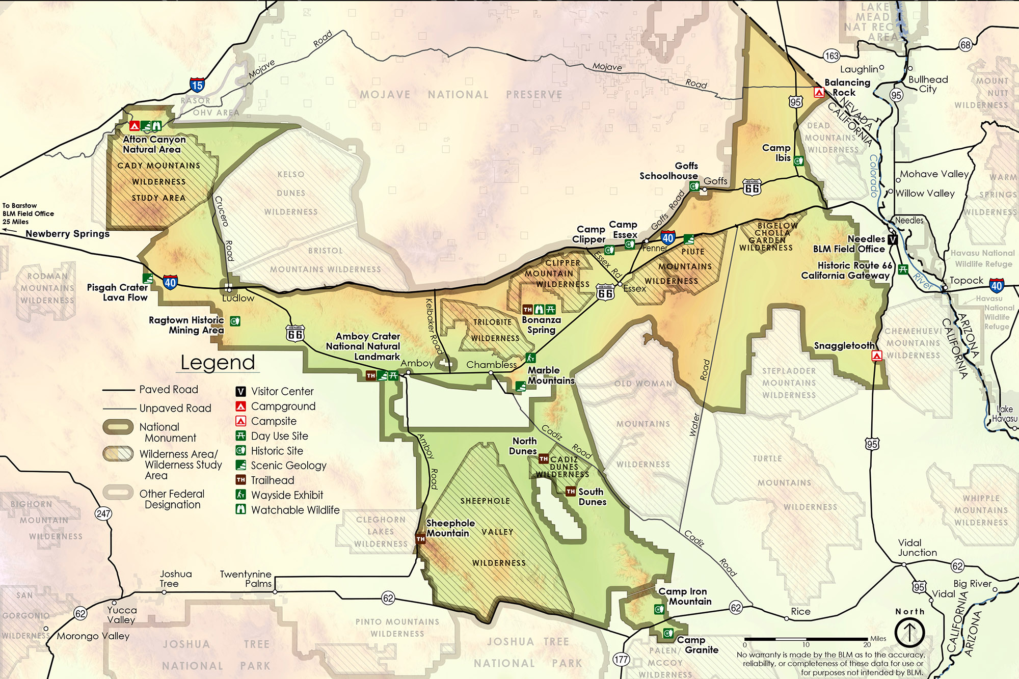
Below is a map created by the BLM of the national monument. You’ll see it looks like a big letter “Y”, with its upper-left side touching Interstate 15, its upper-right side touching the Nevada border, most of its northern border touching the Mojave National Preserve, and its bottom touching the boundary of Joshua Tree National Park. Its size is 1.6 million acres.
Watch the video below for a visual overview of what to see in the Mojave Trails National Monument.
Preservation & Protection
As its name implies, this national monument is dedicated to the preservation and protection of the historic trails etched into the desert landscape. These trails include old wagon roads and others would become the world-famous Route 66. Another invaluable aspect preserved by this national monument is the expansive desert ‘view-scapes’ that early travelers reluctantly negotiated while navigating these ancient paths. Today, visitors can still experience vast stretches of desert untouched by human development.
The monument also encompasses and joins several existing wilderness areas, such as Clipper Mountain, Cadiz Dunes and the Trilobite wildernesses. Other lands are those that have been acquired over a period of more than 20 years by the Wildlands Conservancy, and were then donated to help create a larger swath of protected land.
Historic Trails & Roads
One key objective in establishing the monument was to secure funding and ensure the preservation of various historic roads and trails, hence the monument’s namesake, Mojave Trails. One of the primary roads is Route 66. One of the longest uninterrupted stretches of historic Route 66 passes through Mojave Trails. Unfortunately, many of the bridges for the roadbed that were built in the 1920s are slowly decaying thanks to the desert sun and numerous flash flood events they have endured since being built. Thanks to the new national monument and the County of San Bernardino, efforts are now underway to repair the hundreds of old wooden bridges along this stretch of the historic Mother Road.
Along with Route 66, other historic roads passing through the monument include the Old Spanish Trail, the Old Government Road (known in modern times as the Mojave Road), the Atchison, and Topeka and Santa Fe Railroad that Route 66 mainly followed all the way from Chicago. There are also countless roads and “tracks” that were created during the first years of World War 2 made by nearly a million soldiers training for desert combat under the command of everybody’s favorite general, old “blood and guts” himself, General George S. Patton.


What “National Monument” Means
Many people think that the words, national monument, means that it is land closed to motorized exploration. It isn’t. Wilderness areas are, but they were established decades ago. Much of Mojave Trails National Monument is open to mixed recreation, including hunting and off-road exploring.
The next time you visit this area, plan on checking out one of the places to visit in this new addition to the National Park System. Places include Afton Canyon, Pisgah Crater, Amboy Crater, Cadiz Dunes, and the many swaths of wide-open desert. Learn more about the monument by searching for “Mojave Trails National Monument” on YouTube or scan the QR code below to watch a video tour.
Virtual Video Tour
