Pisgah Crater
Pisgah Crater, sometimes referred to as Pisgah Volcano, is a small volcano known as a cinder cone that has been heavily mined for its unique materials. It also has the largest concentration of lava tubes (caves) in California. Pisgah Crater is located 19 miles (30.5 km) east of Newberry Springs. It’s accessed from historic Route 66.

Trip Specs
Length
2.4 miles (3.8 km) from Route 66
Attractions
- Volcanic landscapes
- Lava/basalt flows
- Lava tubes or caves
- Mining ruins
- Desert scenery
Difficulty
- Deteriorated/bumpy paved road
- Basalt has very sharp edges
- Dangerous cave openings
Elevation Gain
Text, photography and animations by Cliff Bandringa.
Thanks to Bill Smith, Doug Shumway and Keith Fieler for the geologic & mining information.
Since mining operations have been abandoned on the crater itself, the area immediately around it is fun to explore. The lava tubes are very popular with cavers or spelunkers. The lava rock, known as basalt, formed interesting and unique landscapes around the crater to admire and enjoy. The area is accessed using a badly deteriorated paved road. Although the land surrounding the crater is on BLM (public) lands, the crater itself is still on private property, but as of 2025, there are no “no trespassing” signs. The crater abuts the western boundary of the newly established Mojave Trails National Monument.
Geologists are unable to agree as to when Pisgah Crater erupted last. There is evidence that it erupted about three times. Since cinder cones only erupt a few times and then never again, Pisgah Crater will probably not erupt again.
What is a Cinder Cone?
This article about Pisgah Crater is not a substitute for the subject of the much larger subject of volcanism. It will explain some of the basic geology behind what’s going on here.
Cinder cones are mini volcanoes that only erupted a few times, then never again. Real volcanoes, like Mt. St. Helens, erupt over and over again, and over a long period of time, resulting in the creation of large mountains. Cinder cones usually only form small hills, or a single crater, like Pisgah Crater.
Cinder cones can be found all over the Mojave Desert. Some are near Pisgah Crater, such as Amboy Crater and over 30 cinder cones in the Mojave National Preserve.
Cinder cones are created from pockets of magma that were not very large. They usually erupt only a few times, until the magma pocket is empty, then never again. During the eruption(s), the resultant lava flows to lower elevations, then dries to form basalt.
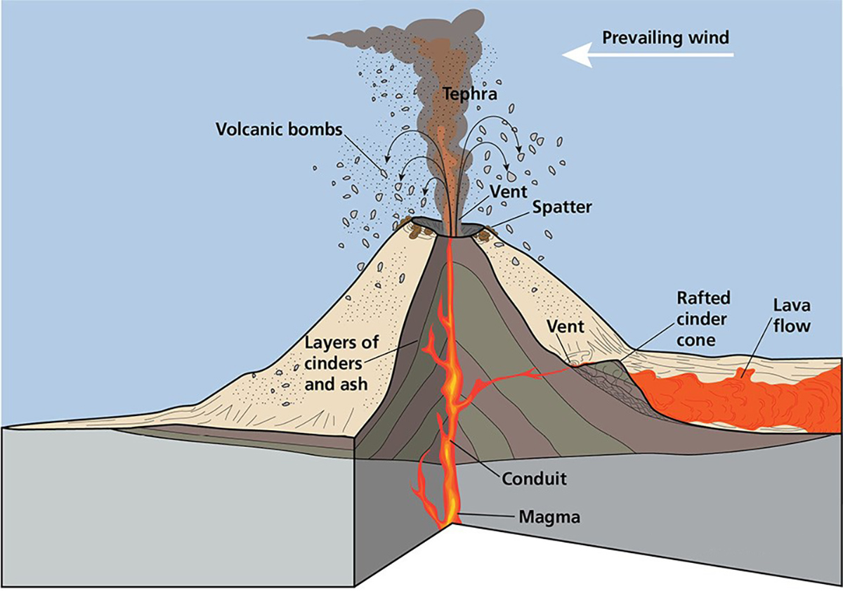
The cross section of a cinder cone above shows how “volcanic bombs” are ejected out of the volcanic vent and accumulate on the side of the cone. The magma chamber below the cone is usually small and the reason why cinder cones erupt a few times, then not again, simply because the chamber ran out of gas.
They’re called cinder cones because the cones are made up of cinder. This is the small gravely lava rock you’ll see laying all around. When it was molten, this cinder was spit out of the center of the cone, then slowly built up as more cinder continued to pile up.
The following pictures show various examples of cinder.


Lavic Lake Fault
In some cases, cinder cones were created from fractures in the Earth’s surface, such as an earthquake fault, where magma crept up to the surface and erupted, becoming lava. Incidentally, a large fault, named the Lavic Lake Fault, passes through the nearby Hector Mine, two miles to the west. One of the more recent larger earthquakes in Southern California occurred at this site. The magnitude 7.1 Hector Mine earthquake occurred on October 16, 1999. Its epicenter was nearby the mine and Pisgah Crater.
From the air, the Lavic Lake Fault is very visible but not noticeable from the ground. The fault slices through another cinder cone six miles to the south of Pisgah Crater and created a ridge of basalt that heads towards the Hector Mine. It then passes through the mine’s open pit and heads northwest across I-40.
This video snippet points out the Lavic Lake Fault and its orientation with Pisgah Crater and the Hector Mine:
More on the Geology
As mentioned, there are no hard facts that lead to a conclusion of how long-ago Pisgah Crater erupted. Some geologists say it erupted as recently as 2,000 years ago, where others say it may have erupted between 20,000 to 50,000 years ago. Apparently, there is no organic material located near the crater, such as wood from a tree, that can be used for any type of scientific dating, such as the method that’s used with other volcanoes. One thing that geologists are certain of is that there is evidence that Pisgah erupted three times.
Pisgah Crater is part of the larger Lavic Lake volcanic field. This field includes four smaller nearby cinder cones and a large volcanic vent about six miles (9.6 km) due south of Pisgah Crater. All of these features created the large lava flows that extend ten miles (16 km) to the northwest and five miles (eight km) to the south. I-40 and Route 66 pass through the western lava flow. The flow contains mainly pahoehoe textured basalt.
Below are examples of pahoehoe basalt that can be found around Pisgah Crater. Also shown is pahoehoe being formed in its molten state (lava) at a volcano in Hawaii. You can easily see the resemblance.


Lava Tubes
The lava that flowed out of Pisgah Crater created many lava tubes. This didn’t occur at other nearby cinder cones such as Amboy Crater. Since lava tubes commonly form in low-viscosity lava, Pisgah’s lava was different than the other area cinder cones. Geologists have identified a whopping 300 lava tubes around the crater, with about 20 that can be explored.
The Hike section below describes a suggested hiking route to find the lava tubes. The pictures below show what some of the lave tubes look like from above and inside.


Mining
Unlike Amboy Crater, which wasn’t mined and scarred at all, Pisgah Crater has been heavily mined. A considerable amount of cinder has been removed from the crater. In addition to the cinder, the volcanic activity around Pisgah Crater and the combination of being near Lavic Dry Lake, unique and rare precious ore developed.
The cinder cone itself has been mined for cinder by a company that served the Santa Fe railroad for several decades. Santa Fe would use the cinder as ballast for their railroad tracks. Cinder hasn’t been mined from here since the 1990s, but reports say that as of 2023, a Canadian Company owns the cinder cone and may mine it in the future.
In 2005, black cinder from Pisgah Crater was mined for a very unique use: the making of a Hollywood movie. The cinder was transported to beaches and studios in the Los Angeles area for filming. In 2007, Clint Eastwood’s film Letters from Iwo Jima was released where the beach scenes contained black sand from Pisgah Crater.
About one mile west of the crater there are several borate deposits that are being mined using liquid injection (water is injected underground bringing the ore to the surface). This mine has recently increased its output as these borate ores are high in lithium, which is currently in high demand due to the need for lithium batteries.
Hector Mine
Two miles west of the crater is the aforementioned Hector Mine. The mineral hectorite was found at this site in 1941 and was named after the locality along the railroad tracks named Hector. There’s a very interesting geologic story on how hectorite was formed here.
The clays that the hectorite is found in were laid down and accumulated over hundreds of thousands of years, as sediments continued depositing into the Lavic (Dry) Lake basin. Basins in the Mojave and Great Basin Deserts have many similar basins where deposits are over 1,000 feet (300 m) thick. Death Valley is a classic example.
By the time Pisgah Crater and other nearby eruptions occurred between 2,000 to 50,000 years ago (see More on Geology above), those clay deposits were buried hundreds of feet deep. The lava warmed up, basically cooked, the clays below. During each eruption, hot lava flowed over the clay deposits, dried, and turned to basalt. Multiple eruptions must have occurred because miners found alternating layers of basalt and clays the deeper they went. These clay deposits were now sealed under the basalt and transformed them into the valuable hectorite.
This was a very unusual and rare chain of events that resulted in the creation of such a rare mineral. There is only one other place on Earth that’s known where a similar process occurred that created hectorite.
Amazingly, a mining prospector in 1941 recognized the potential may exist for rare minerals with the combination of a basalt covered dry lake. They dug beneath the very tough basalt to find the hectorite deposit that appears and feels like old fashioned cake soap. At first, a vertical shaft was dug to extract the ore. As mining technology advanced, the underground workings were later replaced with an open pit mine in the 1970s.
It would later be discovered that hectorite is useful in manufacturing many products. It’s mostly used in making cosmetics. It also has other industrial applications. Hectorite is so valuable, at times its cost per ounce was higher than gold.
The hectorite ore is trucked from the Hector Mine to Newberry Springs and refined in a facility near the railroad tracks, where it is hauled by train to market. The facility sits next to where the old Newberry section house used to stand as described on the History page under Coming of the Railroad.


Getting there
From Newberry Springs, take I-40 east. Take the Hector Road exit, which is about four miles (6.4 km) past a rest area. Go south from I-40, then turn immediately left (east) on to Route 66, which parallels I-40.
Continue east on Route 66. Pisgah Crater will come into the view on the right. At 4.5 miles (7.2 km) from Hector Road, look for a road to the right. It may have a sign saying Pisgah Crater Road. Take this badly deteriorated paved road for about two miles to the base of the cinder cone.
The road will pass by some old mining structures on the west side of the crater. The pavement ends at this point and the road is on cinder from this point on. It climbs up to the crater’s south side and comes to an end at the east side. At this point, the road is very wide, like a parking area. Park at the very end to begin hiking around to look at the surrounding scenery and lava tubes. There is a smaller road that descends and goes down from the parking area and heads north. This road becomes very rough and ends in a quarter of a mile and there’s no advantage to taking it.
The following Google Earth animation shows the approach to and orbit around Pisgah Crater, plus showing the places described in this article:
Hike
From the parking area, find the well-used trail that heads northeast. The trail disappears and you’ll have to find your way around the basalt field. There is no other established trail to lead you around.
WARNING
There are several small lava tubes about 500-1,000 feet (150-300 m) from the parking area. Look for indentations in the basalt. Some of these have small openings, where others have large ones. Some lava tubes have two openings, meaning that you can enter from one end and exit on the other.
Another hiking route is to walk down the rough road from the parking lot that heads north. After descending the hill, bear right into the basalt. There are several lava tubes about 100 feet (30 m) from the road.


Map
Related Articles
- Amboy Crater
- Mojave National Preserve (cinder cone field)