Route 66 Ludlow to Needles
The most remote and barren stretch of Route 66 passes through California’s Mojave Desert between Barstow and the Colorado River, and the touring route described here covers a large portion of it, between the towns of Ludlow and Needles. Even more remote than our other tour of Route 66 between Barstow and Ludlow, this very section was even more remote for early travelers. Today, since this road sees very little traffic, it feels even more remote. Unlike the Barstow to Ludlow section, which is close to its successor I-40 most of the way, this segment is far away from I-40 for its entire length.

Trip Specs
Length
Attractions
- Classic Americana
- Historic old buildings
- Route 66 attractions
- Amboy Crater
- Large desert vistas
Difficulty
- Roads are all paved
- Rough pavement on eastern half
Elevation Gain
The Tour
Although this tour goes from Ludlow to just west of Needles, it can be taken in either direction. If you start from Needles, simply follow the tour itinerary in reverse.
Watch the virtual video tour below for a visual overview of driving this segment of Route 66.
Tour Map
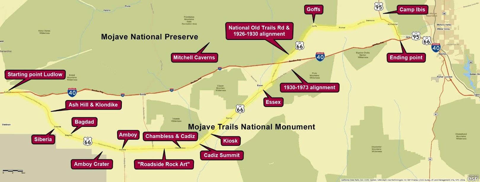
Ludlow
Begin your tour by getting to the town of Ludlow, which is an exit off of I-40. Ludlow is loaded with history. It was the beginning and headquarters of the Tonopah & Tidewater Railroad that operated from 1907 to 1940. Nearby mines pumped a lot of money into this remote desert town.
Behind (to the south of) the current-day café and hotel is where the old downtown existed. Remains of some of the old buildings still exist, including a mercantile store from 1908.
Return to the stop signs on Route 66 and begin heading east away from Ludlow. RESET YOUR TRIP METER here. In a quarter mile, more abandoned buildings will be seen along Route 66. This will be the last signs of civilization until Amboy in 28 miles.
Bridges – Ash Hill – Klondike
About 9.5 miles from Ludlow, Route 66 crosses one of many old wooden bridges, this one longer than most. Many of these bridges are around 100 years old and are withering away in the desert sun and are slowly being replaced or upgraded as funding becomes available.
Near here are the old railroad outposts of Ash Hill and Klondike. Helper steam engines were turned around here to help trains up the long grade from Amboy.
Siberia
At 13.3 miles from Ludlow, a dirt road to the left leads to the remains of Siberia. This was an important water stop for steam engines climbing the long grade between Amboy and Ash Hill. All that remains of Siberia is the foundation and a few walls of a gas station.


Bagdad
At 20.4 miles from Ludlow, a dirt road leads to the site of Bagdad. In its heyday, Bagdad had more going on due to the railroad, such as the station house and rail yard seen in the picture at right, plus there were several nearby mines. Unlike Siberia, where there is one foundation left, there’s nothing left of Bagdad.
Bagdad Café
Located at Bagdad was the “original” Bagdad Café, not the one that has been popularized in Newberry Springs that didn’t come into existence until the 1980s. This was one of many cafes / gas stations / garages / lodging that existed in many of the extinct towns along this tour segment of Route 66
Bagdad Auxiliary Airfield
Across the road from Bagdad (south side) is a memorial for five aviators that were killed while attempting to land at the Bagdad Auxiliary Airfield. They were on a training mission, preparing for the looming air war of World War 2. The accident occurred a few months after the attack on Pearl Harbor on April 9, 1942.


Amboy
There are two placenames along Route 66 with the name Amboy.
Amboy Crater
Seen in the distance from Bagdad, Amboy Crater is a cinder cone, which is like a mini volcano that only erupts a few times. More well-known volcanoes, like Mt. St. Helens erupts many times and becomes large mountains. According to geologists, Amboy Crater erupted around 10,000 years ago.
The entrance to the parking area, picnic tables and restrooms is 26.4 miles from Ludlow. At the end of the parking lot, near the restrooms, is the trailhead to begin a 3 mile round trip hike into the crater. The hike passes by the extensive fields of lava rock, known as basalt. The trail goes around the backside of the crater and climbs up and over a low spot of the crater’s rim. The views of the surrounding volcanic landscape and into the crater to see the explosion pits makes for a very rewarding hike.
Amboy (Town)
At 28 miles from Ludlow, the interesting little town of Amboy is reached. Amboy was founded as a mining town in 1858 and is one of California’s oldest towns. Amboy once boasted a hefty population of about 700.
Amboy has the distinction of once being sold on the on-line auction website, eBay. It is currently owned by the founder of a popular Southern California fast food chain, Juan Pollo. The owner, Albert Okura, made many improvements to the town. Sadly, Okura died in 2023. His family vows to keep the town alive.
“Roadside Rock Art”
Between Amboy and Chambless, unique roadside rock art, or graffiti if you prefer, will be seen on the north or left side of the road. The art will go on for several miles. This tradition was supposedly started in the 1940s by a couple of children that were bored while the vehicle they were riding in broke down. They created the first rock art while their parents fixed their vehicle.


Chambless & Cadiz Area
On the far end of the long valley east of Amboy is the area known as Chambless and Cadiz.
Roadrunner’s Retreat
At 37.5 miles from Ludlow, the ruins of an old truck stop / gas station / restaurant can be seen on the right (south) side of the road. This was Roadrunner’s Retreat that opened in 1962. It is now a Route 66 attraction as it has a well-preserved sign. A group of people are working on restoring the property, as well as lighting up the sign.
Chambless
Just after Roadrunner’s Retreat, Chambless is reached. The railroad first established Cadiz, which is 3 miles to the south. When National Old Trails Road was built around 1910, James and Fannie Chambless opened a service station and store here around 1912. When Route 66 was established in 1926, they moved their store onto the new alignment, which is the road we’re driving on today. Their establishment survived until the early 1980s. The remains of other roadside businesses can be seen nearby.
In the middle of Chambless is a paved road that goes to the south. This is Cadiz Road. It remains paved to the railroad tracks, then it turns to dirt and continues south through the vast Cadiz Valley. Learn more about this area in the Mojave Trails National Monument article.
Cadiz Summit
After heading east from Chambless, the road climbs up and over Cadiz Summit. At the summit you’ll find the burnt remains of the café and gas station of the same name, Cadiz Summit.
Since the ascent to Cadiz Summit is a little steeper than other gradients along desert segments of Route 66, older vehicles of the day had difficulties conquering it in the desert heat. Countless vehicles were repaired here or had to recover from an overheated radiator.
Viewpoint – Kiosk
Just over 2 miles from Cadiz Summit, a pullout with a kiosk will be seen on the right overlooking the vast desert viewscapes, where the only signs of human development might be a passing train. The signs explain various aspects of historic Route 66.
Stretching from Cadiz Summit to Goffs, a distance of about 40 miles, Route 66 will be passing through a vast section of Mojave Desert called Fenner Valley. Very little human development or disturbed land exists in this valley.


Essex
60 miles from Ludlow, the town of Essex is reached. More ruins of old buildings from a vanished time can be seen here. Near the junction of Route 66 and Essex Road is a post office and the remains of the Wayside Garage, Café, Store and Camp.
In 1977, all the residents of Essex, about 50 at the time, appeared on the Tonight Show starring Johnny Carson. Essex had no TV reception back then and Johnny thought it would be interesting to interview a bunch of people that are out of touch with the outside world.
Route 66 Alignment Changes
1.5 miles from Essex, there’s a fork in Route 66. A bridge takes the 1930-1973 alignment of Route 66 over the railroad tracks and straight to I-40. Our tour bears left, following the National Old Trails Road and 1926-1930 alignment of Route 66 through Goffs.
Goffs
The next town encountered is Goffs. This town saw a lot of railroad activity starting in the late 1800s. When National Old Trails Road was established and, later, Route 66, Goffs prospered. When the aforementioned 1930 realignment was completed, most of the traffic took this path, and Goff’s prosperity was dimmed.
Today, people visit Goffs to see its old schoolhouse which now serves as a museum lovingly operated by the Mojave Desert Heritage and Cultural Association. Over the years, this organization has done an outstanding job of preserving many artifacts of the surrounding Mojave Desert.
Intersection With U.S. 95
At 14 miles from Goffs, Route 66 T’s into Route 95. Turning right continues our tour of 66 as it shared the same alignment as 95. However, if you wish to take a quick side trip, turn left and, in 2 miles, you’ll see the historical marker that explains Camp Ibis.
Camp Ibis
Along our tour of Route 66, we passed by three historic World War 2 military training camps: Camp Essex, Camp Clipper and Camp Ibis. Camp Ibis was by far the largest.
During the first half of the war, thousands of troops were trained at these camps under the command of General George S. Patton. The picture at right shows the extensive tent city of Camp Ibis and its roads. These roads can still be seen behind the historical marker, but no other trace of this large encampment remains.
Klinefelter
Continuing on Route 66 & 95 towards I-40, remains of the small town of Klinefelter is reached. Unlike other towns we’ve seen, close by springs provide life to palms and other trees. Honey has been sold here for decades.
From Klinefelter, Route 66 funnels onto I-40, where you can simply follow it for 8 miles into Needles using the modern highway.
Needles
Use exit 141 to follow Route 66’s original alignment through downtown Needles.
Virtual Video Tour
